Senayan, a central district of Jakarta, stands as a reminder of the importance of appreciating local history when tracing the city’s development. Its transformation into a modern business hub reflects Jakarta’s broader socioeconomic changes, yet it was made possible through the sacrifices of the city’s native residents, the Betawi people who accepted displacement in the name of the capital’s progress.
Senayan has become a popular and strategic hub in Kebayoran Baru, South Jakarta, blending business and office life with lifestyle, recreation, and entertainment. It is home to several iconic landmarks, from the multifunctional Gelora Bung Karno Stadium (GBK) to one of the city’s newer ‘green’ destinations, Hutan Kota Plataran and Senayan Park (Spark), which offers a lake, skywalk, and a wide range of culinary experiences that draw residents and visitors alike.
Beyond leisure and commerce, Senayan also holds deep national significance. It was the birthplace of Indonesia’s first national television broadcasts through TVRI, and it continues to serve as a focal point for democracy, housing the House of Representatives (DPR/MPR) building where citizens’ voices and aspirations are channeled into state policy.
What’s in a Name?
The name ‘senayan’ itself has various origins, depending on the historical source. In the book Asal-Usul Nama Tempat di Jakarta (The Origins of Place Names in Jakarta), author Rachmat Ruchiat delves into these different possible origins. The first refers to Wangsanayan, the name of a Balinese person who owned a large plot of residential land, and thus his name was used to refer to this area. Locally, Betawi residents called him Senayan. Proof of this is strengthend by the existence of a map published by the Topographisch Bureau Batavia in 1902 which plotted the the Senayan area at the time under the ‘Wangsanajan.’
Quoting Oud Batavia (1935) compiled by Dr. F. de Haan, Betawi cultural expert Rachmat Ruchiat cited, Senayan could also come from the sanayan tree, the Javanese call it sonokeling (rosewood, dalbergia latifolia). This is would certainly be in tradition of the Betawi people naming regions after plants and trees, like Menteng, Kemang or Pondok Aren.
Alwi Shahab, in his book Batavia Kota Hantu (Batavia, Ghost City), presents another toponymic explanation for the origins of the name Senayan. In the chapter Kampung-Kampung Tua (Old Villages), it says the area derives from the Betawi word senenan, referring to a horse-riding game. This naming was believed to date back to 1808–1811, when Thomas Stamford Raffles served as Governor of the Dutch East Indies and British residents frequently played polo in the area.
Ownership and Acquisition
What is certain is that the Senayan area was once a vast expanse of plantations, rice fields, and villages, including settlements of Balinese people. During the Dutch East Indies era, between the 1860s–1870s, the land was opened for private ownership. One of the earliest known landowners was J.M.L. Bohl, a Dutch immigrant who arrived in Batavia in 1864 at the age of 16. Working hard from a young age, he rose through the ranks at the trading company, Pitcairn Syaae & Co., and eventually Bohl accumulated enough capital to acquire land in two strategic parts of Batavia: Senayan and Matraman.
According to a report in the colonial daily newspaper Het Nieuws van den Dag voor Nederlandsch-Indië, published on 19 June 1920, Bohl owned more than 1,000 hectares of land in Senayan and another 400 hectares in Matraman.
The Dutch-Indies Handbook for Cultivation and Land Management notes: Senajan and Petjandran Wangsanja, a 1,474-bau plot of land in the Batavia Residency, Meester Cornelis District, Kebayoran District, 1.5 miles from Kebayoran. Owner and manager: J.M.L. Bohl. Rental value: 36,000 guilders, population: 1,224 on 1January 1894. Coconut and rice producers. Bohl owned the land since at least 1884, until the coming of the Second World War.
When the Japanese invaded Indonesia, the lands became unclaimed. Control often fell into the hands of local wardens and foremen, who managed the land on behalf of the community. In some cases, entire villages grew out of the efforts of these local leaders, continuing the activities established during the earlier European occupation. After Indonesian independence, around 1950, the Indonesian government decided to take over private land, particularly land owned by the Dutch.
In the Name of Nation-building
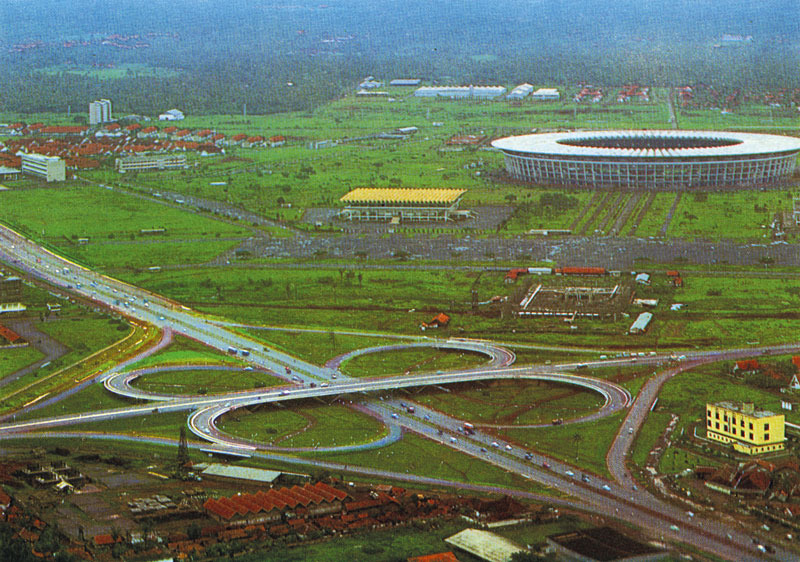
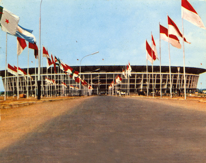
The Senayan area, once a Betawi residential settlement, was transformed into a vast sports complex (GBK Stadium) in preparation for the 1962 Asian Games. GBK Stadium, one of President Sukarno’s most ambitious nation-building projects, came at a significant cost. The construction displaced thousands of Betawi residents, who essentially surrendered their homes and ancestral land in the name of national pride. The total area used for the GBK Stadium itself is approximately 279.8 hectares.

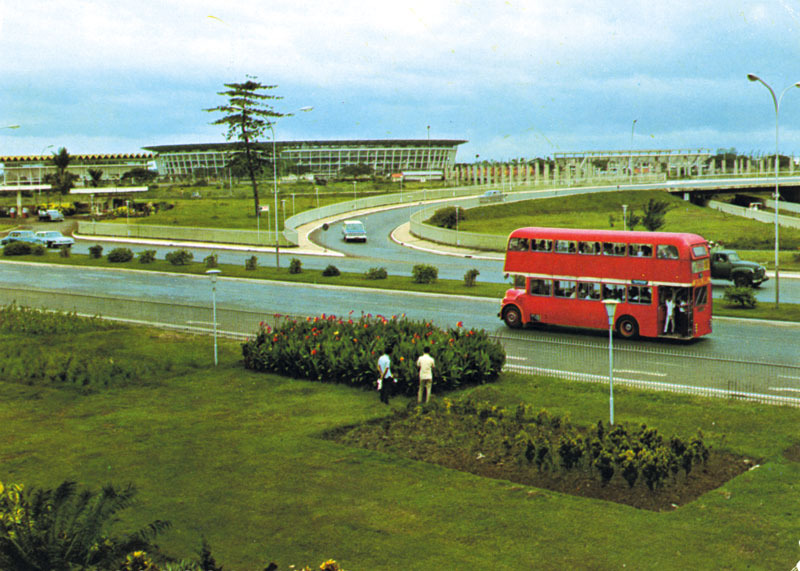
Beyond the stadium, extensive supporting infrastructure was also developed. The TVRI station was built to broadcast the Asian Games and marked Indonesia’s entry into the modern media era, along with the expansion of the city’s transport network, including Bundaran HI and Jembatan Semanggi (Semanggi interchange). Other landmark projects, such as Hotel Indonesia and the Sarinah department store, were also established, underscoring the area’s incredible transformation and evolution.
According to Abud Chaer’s book, Betawi Tempo Doeloe (Betawi in the Past), the evictions in Senayan involved 1,688 houses, kiosks, livestock pens, and the felling of 700,000 trees in Kampung Balur, Kampung Senayan, Petunduan, and Pejompongan. Those residents were provided with understanding and compensation by the central government. Approximately 60,000 residents were relocated to Tebet, Mampang, Condet and several other areas in southern Jakarta to outskirt.

“There were many villages there. My mother liked to tell stories about Petunduan, where Senayan City is now, and Senopati, where Pecandraan used to be. The TVRI tower used to be my grandfather’s garden. My mother told me how she used to play on the swings there, because part of it was used as a yard. The development project was so extensive that to make it easier to pronounce, the area was known by one name, Senayan,” Syahril Ahmad (55 years old) shares with NOW! Jakarta.
In his blog, Syahril also mentions that the Gelora district used to have several village names. The Senayan sports complex development project may have contributed to the disappearance of these long-standing names. Written evidence of the existence of villages in Gelora found on the 1914 Batavia Map, which lists names such as Palmerah, Bendoengan Ilir, Bendoengan Oedik, Pekembangan, Tanahtinggi, Djepang, Merdika, Senajan, Petjandran, Simproek, and Petoendoen.
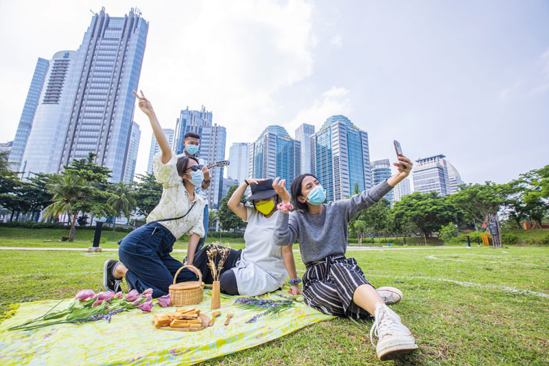
Most of those villages now live only in history, as Senayan today has transformed into a world-class integrated district. It is home to some of Jakarta’s most prestigious hospitality and entertainment destinations, from five-star hotels and upscale malls to vibrant cafés and restaurants. It also stands as one of the capital’s fastest-growing transportation hubs, seamlessly connected by the MRT, LRT, TransJakarta, and Commuter Line/KAI networks.
At its heart lies the GBK Stadium, which has evolved beyond a sports venue into a premier destination for recreation, a stage for prestigious international events, and an inclusive communal space for Jakarta’s residents. Yet, this modern incarnation of Senayan was made possible by the sacrifice and patriotism of its former inhabitants, the Betawi people.